Friday, April 30, 2021

Coly valley hikes: Chapelle Mourat

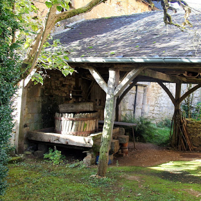
Reminder of the past wine making.
Surrounded by forest this small hamlet was created by monks as a dependency to the monastery of Terrasson. The XIIth century chapel at it’s center, originally dedicated to ‘Our Lady of Maurès’, could accommodate fifteen people. Burned by the 'English' in 1450, it was rebuilt and through a series of transformations the chapel grew into a small church. The monks original purpose for the settlement seems to have been the cultivation of vines.
A living landscape including agricultural activity.
The carte d'état-major (map produced between 1820 and 1866) shows vineyards surrounded the hamlet, just before the 1880 epidemic decimated them. Having lost their purpose, the properties were sold to private individuals. By 1903 there was still a population of 137, today only 9 permanent residents remain going up a little in summer as holiday makers occupy cottages or second homes.
The ‘a bolets’ wine makers houses.
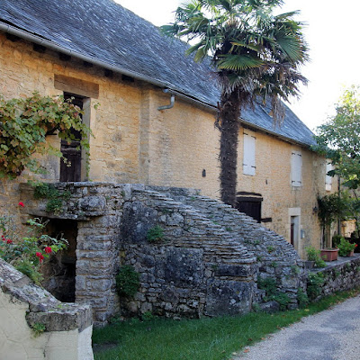
By the 1990’s the local government recognized the unique authenticity and coherence ‘of the whole’(ensemble) worthy of preservation. Constituting elements are: The forest clearing, ‘corderc’, romanesque church (1.), cemetery, enclosure and park of the old presbytery, wine maker’houses with their typical exterior staircases ‘a bolets’ dating from the 17, 18 and 19 centuries, two stone crosses (3.), and walnut plantations. In the Occitan tradition, a couderc refers to the central square around which the village or hamlet is organized which often includes common facilities like the bread oven, fountain, 'travail’ (2.) or place where animals drink.
An authentic hamlet in the heart of a forest.
The challenge to preserve ‘the authentic image of the hamlet in the heart of a forest’ was included in Terrasson’s municipal council’ proposal for a Architectural, Urban and Landscape Heritage Protection Zone (ZPPAUP: Zone de Protection du Patrimoine Architectural, Urbain et Paysager).
Map of Chapelle Mourat.
Bringing together all heritage protection measures; the preservation of sensitive archaeological sites, historic monuments, buildings of architectural interest, homogeneous urban complexes, natural spaces and landscape heritage. The zone, covering nearly 1078 hectares, was created in 1995. Under the proposal the ‘travail’, a device designed to immobilize horses and oxen during shoeing (métier à ferrer) and the bread oven of Chapelle Mourat’s corderc were restaured.
Couderc with the bread oven.
Walking around the hamlet a disused wine press at the back of the church and the 'a bolets’ wine makers houses are reminder of the past wine cultivation. This type of house are a signature for the peasant of the Causses with their living quarters located upstairs whiles the ground floor/basement, provided space for a few animals, workshop and wine making. Because the zone is a living landscape (not a museum) preservation measures do not exclude agricultural activity on the clearing nor the rehabilitation of residential buildings (though subject to certain limitations), they do excludes new constructions other than those required for farming .
Detail of the romanesque church.
Detail of the romanesque church portal.
Chapelle Mourat lies at the southern point of the 17.6 km / 6 hours (or the shortened 12.6 km / 4 h) ‘Boucle de Bouch’ hiking trail starting from Terrasson. Find out more about the landscape, history, vegetation, the villages and life on the causse:

The index of this blog.

No comments:

Post a Comment

The Foire du livre de Brive and the École de Brive.

The posters,bookmarks and leaflets were reprinted, the stickers had a whiff of ‘country’ this year. ‘ Ce qui nous unit tous les cinq n’est...